Geolocate

Lérez topographic map

Click on the map to display elevation.

About this map

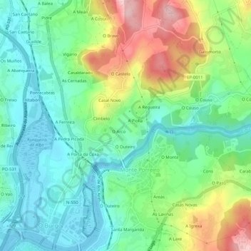
Name: Lérez topographic map, elevation, terrain.

Location: Lérez, Pontevedra, Galicia, España (42.43413 -8.64762 42.47147 -8.61001)

Average elevation: 67 m

Minimum elevation: 0 m

Maximum elevation: 204 m

Other topographic maps

Click on a map to view its topography, its elevation and its terrain.

O Vilar

España > Galicia > Pontevedra > Pontevedra

Average elevation: 153 m

As Pedrosas

España > Galicia > Pontevedra > Pontevedra

Average elevation: 139 m

O Couso

España > Galicia > Pontevedra > Pontevedra

Average elevation: 97 m

Sobral

España > Galicia > Pontevedra > Pontevedra

Average elevation: 110 m

A Pedra do Lagarto

España > Galicia > Pontevedra > Pontevedra

Average elevation: 79 m

A Piolla

España > Galicia > Pontevedra > Pontevedra

Average elevation: 70 m

A Sartán

España > Galicia > Pontevedra > Pontevedra

Average elevation: 55 m

Presa Grande

España > Galicia > Pontevedra > Pontevedra

Average elevation: 313 m

Gear up for your next adventure:

🧣Merino Neck Gaiter - Protects against wind, sun, and cold at high altitudes
🔥Camping Stove - Portable stoves to cook outdoors with ease
🧤Thermal Hiking Gloves - Grip-enhanced gloves for cold-weather altitude trekking
🧴Sunscreen SPF - Broad-spectrum sunscreen for outdoor activities
🔭Compact Monocular - One-handed bird watching and trail spotting

As an Amazon Associate, this site earns from qualifying purchases at no extra cost to you.