
Pichl topographic map
Click on the map to display elevation.
About this map
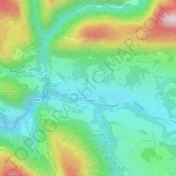
Name: Pichl topographic map, elevation, terrain.
Location: Pichl, Abtenau, Bezirk Hallein, Salzburg, 5441, Austria (47.57686 13.29164 47.61686 13.33164)
Average elevation: 768 m
Minimum elevation: 540 m
Maximum elevation: 1,289 m
Other topographic maps
Click on a map to view its topography, its elevation and its terrain.
Golling an der Salzach
Austria > Salzburg > Bezirk Hallein > Golling an der Salzach
Average elevation: 1,234 m
Salzburg Slate Alps
Austria > Salzburg > Bezirk Hallein
From a topographic perspective there are two subgroups, separated by the Salzach river where it bends northwards near St Johann im Pongau.
Average elevation: 1,412 m