
Thank you for supporting this site ❤️
Make a donation
Make a donation
Gear up for your next adventure:
As an Amazon Associate, this site earns from qualifying purchases at no extra cost to you.
Hallein topographic map
Click on the map to display elevation.
Thank you for supporting this site ❤️
Make a donation
Make a donation
Gear up for your next adventure:
As an Amazon Associate, this site earns from qualifying purchases at no extra cost to you.
About this map
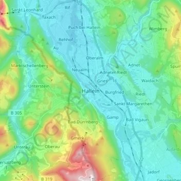
Name: Hallein topographic map, elevation, terrain.
Location: Hallein, Bezirk Hallein, Salzburg, 5400, Austria (47.63292 13.04232 47.73160 13.12878)
Average elevation: 631 m
Minimum elevation: 426 m
Maximum elevation: 1,397 m
Thank you for supporting this site ❤️
Make a donation
Make a donation
Gear up for your next adventure:
As an Amazon Associate, this site earns from qualifying purchases at no extra cost to you.