Geolocate

Génova topographic map

Click on the map to display elevation.

About this map

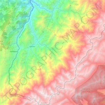
Name: Génova topographic map, elevation, terrain.

Location: Génova, Cordillerana, Quindío, RAP Eje Cafetero, Colombia (4.07521 -75.84310 4.31079 -75.65375)

Average elevation: 2,577 m

Minimum elevation: 1,135 m

Maximum elevation: 4,001 m

Other topographic maps

Click on a map to view its topography, its elevation and its terrain.

Quimbaya

Colombia > Quindío > Quimbaya

Average elevation: 1,306 m

Las Alamos

Colombia > Quindío > Génova

Average elevation: 1,790 m

Gear up for your next adventure:

🥾Mountaineering Boots - Supportive boots for climbing and high-altitude hiking
🔨Vehicle Emergency Tool - Safety tool for remote road trips to trailheads
🥾Approach Boots - Comfortable boots for hiking and climbing approaches
🥾Approach Shoes - Shoes designed for climbing approaches and rugged trails
🧭GPS Tracker - Track your location in remote areas safely

As an Amazon Associate, this site earns from qualifying purchases at no extra cost to you.