
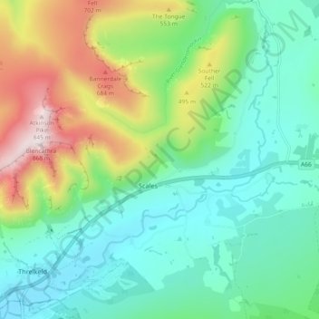
River Glenderamackin topographic map
Interactive map
Click on the map to display elevation.
About this map
Name: River Glenderamackin topographic map, elevation, terrain.
Average elevation: 346 m
Minimum elevation: 134 m
Maximum elevation: 854 m
Other topographic maps
Click on a map to view its topography, its elevation and its terrain.
Blease Fell
United Kingdom > England > Westmorland and Furness > Threlkeld
Blease Fell, Threlkeld, Westmorland and Furness, England, CA12 4SF, United Kingdom
Average elevation: 482 m
Wescoe
United Kingdom > England > Westmorland and Furness > Threlkeld
Wescoe, Threlkeld, Westmorland and Furness, England, CA12 4TB, United Kingdom
Average elevation: 279 m
Blencathra
United Kingdom > England > Westmorland and Furness > Threlkeld
Blencathra, Threlkeld, Westmorland and Furness, England, CA12 4SU, United Kingdom
Average elevation: 577 m