Geolocate

Rubizhne topographic map

Click on the map to display elevation.

About this map

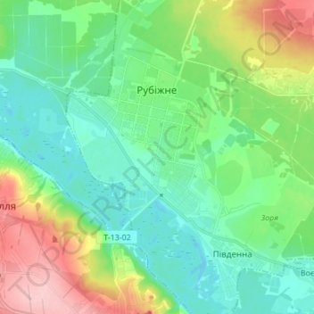
Name: Rubizhne topographic map, elevation, terrain.

Location: Rubizhne, Рубіжанська міська громада, Sievierodonetsk Raion, Luhansk Oblast, Ukraine (48.96873 38.33300 49.05836 38.43721)

Average elevation: 88 m

Minimum elevation: 44 m

Maximum elevation: 196 m

Other topographic maps

Click on a map to view its topography, its elevation and its terrain.

16

Ukraine > Luhansk Oblast > Luhansk

Average elevation: 114 m

Ananivka

Ukraine > Luhansk Oblast > Sverdlovsk Raion

Average elevation: 296 m

Novoselivske

Ukraine > Luhansk Oblast

Average elevation: 173 m

Raihorodka

Ukraine > Luhansk Oblast

Average elevation: 59 m

Stelmakhivka

Ukraine > Luhansk Oblast

The village is located near the border of Luhansk and Kharkiv Oblasts. 20 kilometers from Svatove and 23 kilometers from the urban settlement of Borova. Administratively, the village was arranged into the Svatove Raion in 2020. The elevation is 146 meters.

Average elevation: 169 m

Lysychansk

Ukraine > Luhansk Oblast > Lysychansk

Average elevation: 115 m

Pavlivka

Ukraine > Luhansk Oblast

Average elevation: 198 m

Gear up for your next adventure:

🔋Solar Power Bank - Keep your GPS and devices charged during long outdoor trips
👟Leg Gaiters - Keep debris, mud, and snow out of your boots
🪑Insulated Seat Pad - Protect your seat from cold rocks and wet logs
🥾Trail Running Boots - Durable shoes designed for trail running
🎒Fully Waterproof Backpack - Total protection for photography gear and electronics

As an Amazon Associate, this site earns from qualifying purchases at no extra cost to you.