Geolocate

Jantho topographic map

Click on the map to display elevation.

About this map

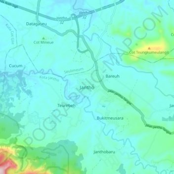
Name: Jantho topographic map, elevation, terrain.

Location: Jantho, Kota Jantho, Aceh Besar, Aceh, Sumatra, Indonesia (5.26372 95.55037 5.34372 95.63037)

Average elevation: 104 m

Minimum elevation: 47 m

Maximum elevation: 496 m

Other topographic maps

Click on a map to view its topography, its elevation and its terrain.

Mesjid Raya

Indonesia > Aceh > Aceh Besar

Average elevation: 109 m

Montasik

Indonesia > Aceh > Aceh Besar

Average elevation: 131 m

Indrapuri

Indonesia > Aceh > Aceh Besar

Average elevation: 183 m

Seulimeum

Indonesia > Aceh > Aceh Besar

Average elevation: 208 m

Darussalam

Indonesia > Aceh > Aceh Besar

Average elevation: 107 m

Montasik

Indonesia > Aceh > Aceh Besar

Average elevation: 131 m

Kuta Malaka

Indonesia > Aceh > Aceh Besar

Average elevation: 121 m

Gear up for your next adventure:

🧢Outdoor Cap - Protective cap for sun and rain during hikes
🥾Hiking Shorts - Breathable shorts suitable for summer hikes
🩹Compact First Aid Kit - Pre-packed essentials for common trail injuries
🧴Waterproofing Spray - Restore the DWR coating on jackets and tents
🔦LED Headtorch - Bright and durable light for night activities

As an Amazon Associate, this site earns from qualifying purchases at no extra cost to you.