Geolocate

Indrapuri topographic map

Click on the map to display elevation.

About this map

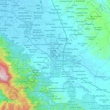
Name: Indrapuri topographic map, elevation, terrain.

Location: Indrapuri, Aceh Besar, Aceh, Sumatra, Indonesia (5.30189 95.34314 5.53361 95.57253)

Average elevation: 183 m

Minimum elevation: 4 m

Maximum elevation: 1,620 m

Other topographic maps

Click on a map to view its topography, its elevation and its terrain.

Lamteubadroe

Indonesia > Aceh > Aceh Besar

Average elevation: 278 m

Jantho

Indonesia > Aceh > Aceh Besar

Average elevation: 104 m

Lamtamot

Indonesia > Aceh > Aceh Besar

Average elevation: 193 m

Babah Jurong

Indonesia > Aceh > Aceh Besar

Average elevation: 52 m

Bueng

Indonesia > Aceh > Aceh Besar

Average elevation: 137 m

Paran

Indonesia > Aceh > Aceh Besar

Average elevation: 131 m

Gear up for your next adventure:

🌡️Emergency Mylar Blankets - Compact thermal protection for unexpected nights outdoors
🦌Outdoor Trail Camera - Monitor wildlife activity near your favorite spots
💡Portable Camping Lamp - Rechargeable lamp for campsite lighting
🧭GPS Outdoor Watch - Smart watch for navigation and fitness tracking in nature
🏃Hydration Running Vest - Carry water and maps close to your body for speed

As an Amazon Associate, this site earns from qualifying purchases at no extra cost to you.