Geolocate

Galena topographic map

Click on the map to display elevation.

About this map

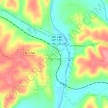
Name: Galena topographic map, elevation, terrain.

Location: Galena, Stone County, Missouri, United States (36.79811 -93.48362 36.81473 -93.46204)

Average elevation: 323 m

Minimum elevation: 280 m

Maximum elevation: 375 m

Other topographic maps

Click on a map to view its topography, its elevation and its terrain.

Cape Fair

United States > Missouri > Stone County

Average elevation: 308 m

Viola

United States > Missouri > Stone County

Average elevation: 301 m

Cape Fair

United States > Missouri > Stone County

Average elevation: 308 m

Notch

United States > Missouri > Stone County

Average elevation: 348 m

Notch

United States > Missouri > Stone County > Notch

Average elevation: 348 m

Gear up for your next adventure:

👟Sport Hiking Sandals - Breathable footwear for water crossings and camp rest
Lightweight Backpacking Tent - Compact tent for efficient hiking trips
🔨Vehicle Emergency Tool - Safety tool for remote road trips to trailheads
🧥Softshell Jacket - Windproof and breathable jacket for hiking
🎒Hiking Backpack - Lightweight and ergonomic backpacks for day hikes or multi-day treks

As an Amazon Associate, this site earns from qualifying purchases at no extra cost to you.