Geolocate

Notch topographic map

Click on the map to display elevation.

About this map

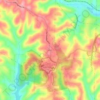
Name: Notch topographic map, elevation, terrain.

Location: Notch, Stone County, Missouri, 65737, United States (36.65609 -93.35854 36.69609 -93.31854)

Average elevation: 348 m

Minimum elevation: 268 m

Maximum elevation: 415 m

Other topographic maps

Click on a map to view its topography, its elevation and its terrain.

Galena

United States > Missouri > Stone County

Average elevation: 323 m

Branson West

United States > Missouri > Stone County

Average elevation: 382 m

Galena

United States > Missouri > Stone County

Average elevation: 323 m

Blue Eye, MO

United States > Missouri > Stone County

Average elevation: 382 m

Reeds Spring

United States > Missouri > Stone County

Average elevation: 399 m

Gear up for your next adventure:

🥾Approach Boots - Comfortable boots for hiking and climbing approaches
🧭GPS Outdoor Watch - Smart watch for navigation and fitness tracking in nature
🧴Insect Repellent - Protect yourself from bugs during outdoor adventures
🧥Thermal Fleece Jacket - Versatile insulation for changing mountain temperatures
🛶Canoe Life Vest - Safety vest for water sports

As an Amazon Associate, this site earns from qualifying purchases at no extra cost to you.