Geolocate

Tamsweg topographic map

Click on the map to display elevation.

About this map

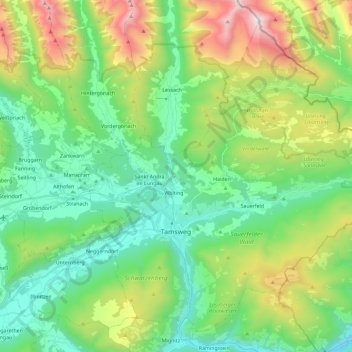
Name: Tamsweg topographic map, elevation, terrain.

Location: Tamsweg, Bezirk Tamsweg, Salzburg, 5580, Austria (47.08162 13.76642 47.21993 13.99613)

Average elevation: 1,449 m

Minimum elevation: 911 m

Maximum elevation: 2,727 m

Other topographic maps

Click on a map to view its topography, its elevation and its terrain.

Wastlalm

Austria > Salzburg > Bezirk Tamsweg > Zederhaus

Average elevation: 1,769 m

Rothenwand

Austria > Salzburg > Bezirk Tamsweg

Average elevation: 1,674 m

Fanningberg

Austria > Salzburg > Bezirk Tamsweg > Steindorf

Average elevation: 1,296 m

Prebersee

Austria > Salzburg > Bezirk Tamsweg > Tamsweg

Average elevation: 1,620 m

Gear up for your next adventure:

Camping Tent - Weather-resistant tents suitable for 2 to 6 people
💡LED Camping Lantern - Illuminate your campsite with long-lasting lanterns
🥾Trail Running Boots - Durable shoes designed for trail running
🧦Crew Hiking Socks - Comfortable socks for long-distance hikes
🕯️Camping Lantern - Illuminates your entire campsite with high-efficiency LEDs

As an Amazon Associate, this site earns from qualifying purchases at no extra cost to you.