Geolocate

Chetumal topographic map

Click on the map to display elevation.

About this map

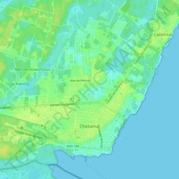
Name: Chetumal topographic map, elevation, terrain.

Location: Chetumal, Othón P. Blanco, Quintana Roo, Mexico (18.49021 -88.35772 18.56351 -88.26114)

Average elevation: 5 m

Minimum elevation: 0 m

Maximum elevation: 16 m

Other topographic maps

Click on a map to view its topography, its elevation and its terrain.

Mahahual

Mexico > Quintana Roo > Othón P. Blanco

Average elevation: 2 m

Mahahual

Mexico > Quintana Roo > Othón P. Blanco

Average elevation: 2 m

Gear up for your next adventure:

🥾Trekking Poles - Adjustable trekking poles to reduce knee stress and improve stability
🥾Approach Shoes - Shoes designed for climbing approaches and rugged trails
🔥Camping Stove - Portable stoves to cook outdoors with ease
🥾Mountain Hiking Shoes - Shoes with superior grip for mountainous terrain
💡LED Camping Lantern - Illuminate your campsite with long-lasting lanterns

As an Amazon Associate, this site earns from qualifying purchases at no extra cost to you.