Geolocate

Ballabio topographic map

Click on the map to display elevation.

About this map

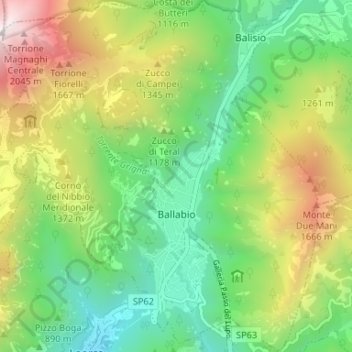
Name: Ballabio topographic map, elevation, terrain.

Location: Ballabio, Lecco, Lombardy, 23811, Italy (45.88018 9.39086 45.92601 9.44984)

Average elevation: 1,053 m

Minimum elevation: 429 m

Maximum elevation: 2,134 m

Other topographic maps

Click on a map to view its topography, its elevation and its terrain.

Vassena

Italy > Lombardy > Lecco > Oliveto Lario

Average elevation: 426 m

Monte Resegone

Italy > Lombardy > Lecco > Lecco

Average elevation: 1,371 m

Travecchia

Italy > Lombardy > Lecco > Ca' Nova

Average elevation: 387 m

Consonno

Italy > Lombardy > Lecco > Olginate

Average elevation: 486 m

Gear up for your next adventure:

🧭GPS Tracker - Track your location in remote areas safely
🧳Compression Sacks - Maximize space in your backpack by shrinking gear
🦟Insect Repellent - Keep mosquitoes and black flies away in wooded areas
📷Outdoor Action Camera - Capture high-elevation views and rugged adventures
🥾Mountain Hiking Shoes - Shoes with superior grip for mountainous terrain

As an Amazon Associate, this site earns from qualifying purchases at no extra cost to you.