
Make a donation
Gear up for your next adventure:
As an Amazon Associate, this site earns from qualifying purchases at no extra cost to you.
North Island topographic map
Click on the map to display elevation.
Make a donation
Gear up for your next adventure:
As an Amazon Associate, this site earns from qualifying purchases at no extra cost to you.
About this map
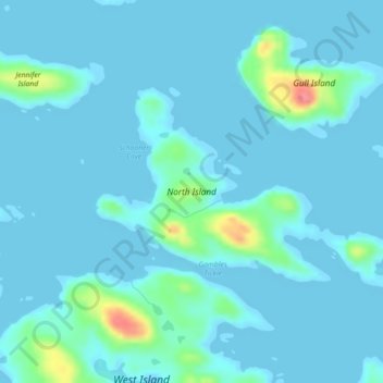
Name: North Island topographic map, elevation, terrain.
Location: North Island, Labrador, Terre-Neuve et Labrador, Canada (52.80872 -55.85466 52.82342 -55.81480)
Average elevation: 8 m
Minimum elevation: -2 m
Maximum elevation: 75 m
Make a donation
Gear up for your next adventure:
As an Amazon Associate, this site earns from qualifying purchases at no extra cost to you.
Other topographic maps
Click on a map to view its topography, its elevation and its terrain.
Cirque Mountain
Canada > Terre-Neuve et Labrador
Cirque Mountain est une montagne de 1 568 mètres d'altitude située à l'extrémité nord-est de la péninsule du Québec-Labrador au Labrador dans la province de Terre-Neuve-et-Labrador. La montagne est située dans les monts Torngat, dans le territoire autonome du Nunatsiavut.
Average elevation: 1,232 m
Make a donation
Gear up for your next adventure:
As an Amazon Associate, this site earns from qualifying purchases at no extra cost to you.
Make a donation
Gear up for your next adventure:
As an Amazon Associate, this site earns from qualifying purchases at no extra cost to you.