
Make a donation
Gear up for your next adventure:
As an Amazon Associate, this site earns from qualifying purchases at no extra cost to you.
The Red House topographic map
Click on the map to display elevation.
Make a donation
Gear up for your next adventure:
As an Amazon Associate, this site earns from qualifying purchases at no extra cost to you.
About this map
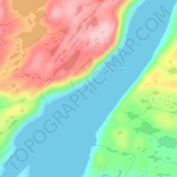
Name: The Red House topographic map, elevation, terrain.
Location: The Red House, Terre-Neuve, Terre-Neuve et Labrador, Canada (47.64293 -58.63414 47.64336 -58.63371)
Average elevation: 71 m
Minimum elevation: 0 m
Maximum elevation: 186 m
Make a donation
Gear up for your next adventure:
As an Amazon Associate, this site earns from qualifying purchases at no extra cost to you.
Other topographic maps
Click on a map to view its topography, its elevation and its terrain.
Make a donation
Gear up for your next adventure:
As an Amazon Associate, this site earns from qualifying purchases at no extra cost to you.
Cirque Mountain
Canada > Terre-Neuve et Labrador
Cirque Mountain est une montagne de 1 568 mètres d'altitude située à l'extrémité nord-est de la péninsule du Québec-Labrador au Labrador dans la province de Terre-Neuve-et-Labrador. La montagne est située dans les monts Torngat, dans le territoire autonome du Nunatsiavut.
Average elevation: 1,232 m
Make a donation
Gear up for your next adventure:
As an Amazon Associate, this site earns from qualifying purchases at no extra cost to you.
Make a donation
Gear up for your next adventure:
As an Amazon Associate, this site earns from qualifying purchases at no extra cost to you.
Benie Island
Canada > Terre-Neuve et Labrador > unincorporated Newfoundland > Port au Choix
Average elevation: 9 m
Pressons Island
Canada > Terre-Neuve et Labrador > Joe Batt's Arm-Barr'd Islands-Shoal Bay > Joe Batt’s Arm
Average elevation: 9 m
Make a donation
Gear up for your next adventure:
As an Amazon Associate, this site earns from qualifying purchases at no extra cost to you.