Geolocate

Drochtersen topographic map

Click on the map to display elevation.

About this map

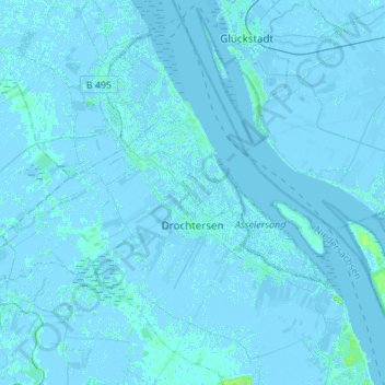
Name: Drochtersen topographic map, elevation, terrain.

Location: Drochtersen, Stade, Lower Saxony, 21706, Germany (53.64929 9.22945 53.79647 9.50200)

Average elevation: 0 m

Minimum elevation: -4 m

Maximum elevation: 15 m

Other topographic maps

Click on a map to view its topography, its elevation and its terrain.

Hamelwörden

Germany > Lower Saxony > Stade

Average elevation: 0 m

Hörne

Germany > Lower Saxony > Stade

Average elevation: 0 m

Börne

Germany > Lower Saxony > Stade > Stade

Average elevation: 5 m

Gear up for your next adventure:

🧥Softshell Hiking Jacket - The perfect balance of wind protection and breathability
🧥Waterproof Pants - Keep dry during rainy hiking conditions
🥾Hiking Gaiters - Protect legs and shoes from mud, snow, and debris
🦶Anti-Blister Balm - Prevents friction and hotspots during long ascents
🥾Trekking Poles - Adjustable trekking poles to reduce knee stress and improve stability

As an Amazon Associate, this site earns from qualifying purchases at no extra cost to you.