Geolocate

Kalmar topographic map

Click on the map to display elevation.

About this map

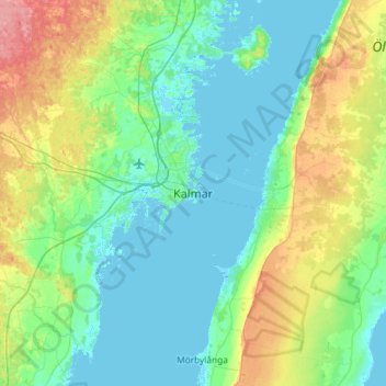
Name: Kalmar topographic map, elevation, terrain.

Location: Kalmar, Kalmar kommun, Kalmar County, 392 31, Sweden (56.50288 16.20624 56.82288 16.52624)

Average elevation: 17 m

Minimum elevation: -2 m

Maximum elevation: 73 m

Other topographic maps

Click on a map to view its topography, its elevation and its terrain.

Emmaboda kommun

Sweden > Kalmar County

Average elevation: 141 m

Hansa City

Sweden > Kalmar County

Average elevation: 7 m

Högsby kommun

Sweden > Kalmar County

Average elevation: 97 m

Nybro kommun

Sweden > Kalmar County

Average elevation: 109 m

Hultsfreds kommun

Sweden > Kalmar County

Average elevation: 143 m

Store Hindsjön

Sweden > Kalmar County

Average elevation: 118 m

Mönsterås kommun

Sweden > Kalmar County

Average elevation: 26 m

Alen

Sweden > Kalmar County

Average elevation: 142 m

Emmaboda kommun

Sweden > Kalmar County

Average elevation: 141 m

Oskarshamns kommun

Sweden > Kalmar County

Average elevation: 63 m

Kalmar kommun

Sweden > Kalmar County

Average elevation: 28 m

Gear up for your next adventure:

🧣Merino Neck Gaiter - Protects against wind, sun, and cold at high altitudes
👟Trail Running Shoes - Agile footwear for fast-paced topographic exploration
🚲Heavy Duty Bike Lock - Secure your bike at the trailhead or during stops
🎒Fully Waterproof Backpack - Total protection for photography gear and electronics
🥾All-Terrain Hiking Boots - Versatile boots for varied hiking conditions

As an Amazon Associate, this site earns from qualifying purchases at no extra cost to you.