Geolocate

Somerville topographic map

Click on the map to display elevation.

About this map

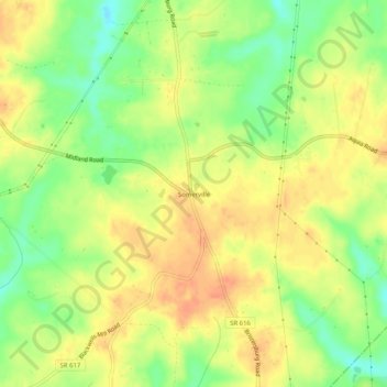
Name: Somerville topographic map, elevation, terrain.

Location: Somerville, Fauquier County, Virginia, United States (38.50179 -77.62943 38.54179 -77.58943)

Average elevation: 117 m

Minimum elevation: 92 m

Maximum elevation: 134 m

Other topographic maps

Click on a map to view its topography, its elevation and its terrain.

Bealeton

United States > Virginia > Fauquier County > Bealeton

Average elevation: 100 m

Marshall

United States > Virginia > Fauquier County

Average elevation: 189 m

New Baltimore

United States > Virginia > Fauquier County

Average elevation: 148 m

Rectortown

United States > Virginia > Fauquier County

Average elevation: 161 m

Upperville

United States > Virginia > Fauquier County

Average elevation: 172 m

Broad Run

United States > Virginia > Fauquier County > Broad Run

Average elevation: 164 m

Gear up for your next adventure:

📷Outdoor Action Camera - Capture high-elevation views and rugged adventures
🥾Lightweight Hiking Boots - Boots for comfort and mobility on long hikes
🥾Waterproof Hiking Boots - Essential footwear for rugged terrain and wet Canadian trails
🧭GPS Handheld Device - Reliable GPS navigation for outdoor adventures
🛶Kayak Dry Bag - Waterproof storage for kayaking adventures

As an Amazon Associate, this site earns from qualifying purchases at no extra cost to you.