
Grass Valley topographic map
Click on the map to display elevation.
Grass Valley
Grass Valley is a city in Nevada County, California, United States. As of the 2010 United States Census, its population was 12,860. Situated at roughly 2,500 feet (760 m) in elevation in the western foothills of the Sierra Nevada mountain range, this northern Gold Country city is 57 miles (92 km) by car from Sacramento and 88 miles (142 km) west of Reno.
About this map
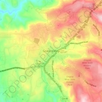
Name: Grass Valley topographic map, elevation, terrain.
Location: Grass Valley, Nevada County, California, United States (39.19381 -121.08282 39.24408 -121.00559)
Average elevation: 775 m
Minimum elevation: 618 m
Maximum elevation: 921 m
Other topographic maps
Click on a map to view its topography, its elevation and its terrain.
Empire Mine State Historic Park
United States > California > Nevada County > Grass Valley > Boston Ravine
Average elevation: 795 m
Nevada County Fairgrounds
United States > California > Nevada County > Grass Valley > Boston Ravine
Average elevation: 743 m