
Boston Ravine topographic map
Click on the map to display elevation.
About this map
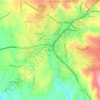
Name: Boston Ravine topographic map, elevation, terrain.
Average elevation: 755 m
Minimum elevation: 667 m
Maximum elevation: 858 m
Other topographic maps
Click on a map to view its topography, its elevation and its terrain.
Empire Mine State Historic Park
United States > California > Nevada County > Grass Valley > Boston Ravine
Average elevation: 795 m
Nevada County Fairgrounds
United States > California > Nevada County > Grass Valley > Boston Ravine
Average elevation: 743 m