Geolocate

Carsonville topographic map

Click on the map to display elevation.

About this map

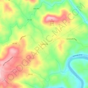
Name: Carsonville topographic map, elevation, terrain.

Location: Carsonville, Grayson County, Virginia, United States (36.65735 -81.08953 36.69735 -81.04953)

Average elevation: 786 m

Minimum elevation: 674 m

Maximum elevation: 912 m

Other topographic maps

Click on a map to view its topography, its elevation and its terrain.

Independence

United States > Virginia > Grayson County

Average elevation: 817 m

Fries

United States > Virginia > Grayson County

Average elevation: 710 m

Fries

United States > Virginia > Grayson County

Average elevation: 710 m

Independence

United States > Virginia > Grayson County

Average elevation: 817 m

Troutdale

United States > Virginia > Grayson County

Average elevation: 999 m

Troutdale

United States > Virginia > Grayson County

Average elevation: 999 m

Gear up for your next adventure:

🔭Compact Binoculars - Lightweight optics for scouting trails and wildlife
🧴Waterproofing Spray - Restore the DWR coating on jackets and tents
💧Filtered Water Bottle - Safe drinking water on the go
🥘Camping Cookware Set - Compact nesting pots and pans for trail cooking
🧊Portable Cooler - Keep food and drinks cold during outdoor adventures

As an Amazon Associate, this site earns from qualifying purchases at no extra cost to you.