Geolocate

Monte Romano topographic map

Click on the map to display elevation.

About this map

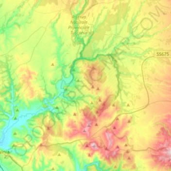
Name: Monte Romano topographic map, elevation, terrain.

Location: Monte Romano, Viterbo, Lazio, Italy (42.23071 11.85182 42.42706 11.96720)

Average elevation: 162 m

Minimum elevation: 17 m

Maximum elevation: 393 m

Other topographic maps

Click on a map to view its topography, its elevation and its terrain.

Monte Raschio

Italy > Lazio > Viterbo > Oriolo Romano

Average elevation: 448 m

Bagnaia

Italy > Lazio > Viterbo > Viterbo

Average elevation: 464 m

Isola Bisentina

Italy > Lazio > Viterbo > Capodimonte

Average elevation: 304 m

Cura

Italy > Lazio > Viterbo > Vetralla

Average elevation: 393 m

Gear up for your next adventure:

🥾Waterproof Trail Shoes - Shoes designed to handle wet terrain
Camping Tent - Weather-resistant tents suitable for 2 to 6 people
🧤Insulated Winter Gloves - Heavy-duty protection for sub-zero Canadian adventures
🥾Light Trekking Boots - Supportive boots for multi-day treks
🧼Biodegradable Camp Soap - Environmentally friendly cleaning for gear and body

As an Amazon Associate, this site earns from qualifying purchases at no extra cost to you.