
Make a donation
Gear up for your next adventure:
As an Amazon Associate, this site earns from qualifying purchases at no extra cost to you.
Kearny topographic map
Click on the map to display elevation.
Make a donation
Gear up for your next adventure:
As an Amazon Associate, this site earns from qualifying purchases at no extra cost to you.
Kearny
The town is varied in topography and roughly divided into three parts: the Kearny Uplands, the Kearny Meadows and South Kearny, where the Hackensack and Passaic rivers meet. Main thoroughfares include the eponymous Kearny Avenue (the local segment of Ridge Road / Frank E. Rodgers Boulevard), Bergen Avenue, Midland Avenue, Schuyler Avenue and Passaic Avenue.
Make a donation
Gear up for your next adventure:
As an Amazon Associate, this site earns from qualifying purchases at no extra cost to you.
About this map
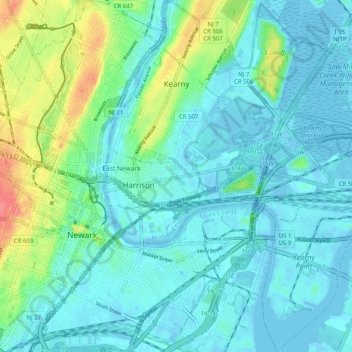
Name: Kearny topographic map, elevation, terrain.
Location: Kearny, Hudson County, New Jersey, 07032, United States (40.71060 -74.16475 40.78649 -74.07475)
Average elevation: 14 m
Minimum elevation: -6 m
Maximum elevation: 65 m
Make a donation
Gear up for your next adventure:
As an Amazon Associate, this site earns from qualifying purchases at no extra cost to you.
Other topographic maps
Click on a map to view its topography, its elevation and its terrain.
Croxton
United States > New Jersey > Hudson County > Jersey City > Journal Square
Average elevation: 16 m
Make a donation
Gear up for your next adventure:
As an Amazon Associate, this site earns from qualifying purchases at no extra cost to you.
North Hudson Park
United States > New Jersey > Hudson County > North Bergen > Hudson Heights
Average elevation: 41 m
Make a donation
Gear up for your next adventure:
As an Amazon Associate, this site earns from qualifying purchases at no extra cost to you.
Bergen Square
United States > New Jersey > Hudson County > Jersey City > Journal Square
Average elevation: 13 m
Marion
United States > New Jersey > Hudson County > Jersey City > Journal Square
Average elevation: 12 m
Make a donation
Gear up for your next adventure:
As an Amazon Associate, this site earns from qualifying purchases at no extra cost to you.
Croxton
United States > New Jersey > Hudson County > Jersey City > Journal Square
Average elevation: 16 m
Make a donation
Gear up for your next adventure:
As an Amazon Associate, this site earns from qualifying purchases at no extra cost to you.
Hudson River Waterfront
United States > New Jersey > Hudson County > Jersey City
Average elevation: 2 m
North End Business District
United States > New Jersey > Hudson County > Secaucus
Average elevation: 4 m
Bergen Square
United States > New Jersey > Hudson County > Jersey City > Journal Square
Average elevation: 13 m
Make a donation
Gear up for your next adventure:
As an Amazon Associate, this site earns from qualifying purchases at no extra cost to you.