
Make a donation
Gear up for your next adventure:
As an Amazon Associate, this site earns from qualifying purchases at no extra cost to you.
Communipaw topographic map
Click on the map to display elevation.
Make a donation
Gear up for your next adventure:
As an Amazon Associate, this site earns from qualifying purchases at no extra cost to you.
About this map
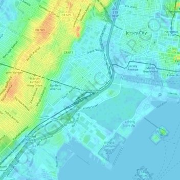
Name: Communipaw topographic map, elevation, terrain.
Average elevation: 8 m
Minimum elevation: -7 m
Maximum elevation: 33 m
Make a donation
Gear up for your next adventure:
As an Amazon Associate, this site earns from qualifying purchases at no extra cost to you.
Other topographic maps
Click on a map to view its topography, its elevation and its terrain.
Ellis Island
United States > New Jersey > Hudson County > Jersey City > Communipaw
The first floor contained detention rooms, social service offices, and waiting rooms on its west wing, a use that remained relatively unchanged. The central space was initially a baggage room until 1907, but was subsequently subdivided and later re-combined into a single records room. The first floor's east…
Average elevation: 1 m