Geolocate

Anson topographic map

Click on the map to display elevation.

About this map
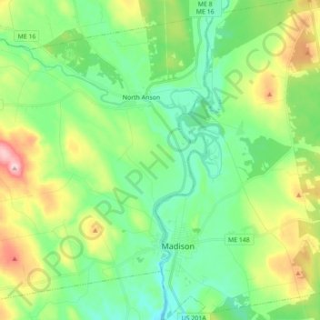
Name: Anson topographic map, elevation, terrain.

Location: Anson, Somerset County, Maine, 04911, United States (44.77383 -70.03327 44.88758 -69.85908)

Average elevation: 123 m

Minimum elevation: 48 m

Maximum elevation: 293 m

Other topographic maps

Click on a map to view its topography, its elevation and its terrain.
Pratt Hill

United States > Maine > Somerset County > Skowhegan

Average elevation: 113 m

Bigelow Hill

United States > Maine > Somerset County > Skowhegan

Average elevation: 158 m

Mackamp

United States > Maine > Somerset County

Average elevation: 395 m

Gray Island

United States > Maine > Somerset County > Solon

Average elevation: 105 m

Norris Brook

United States > Maine > Somerset County

Average elevation: 420 m

Gear up for your next adventure:

🥾Mountain Trail Shoes - High-traction shoes for mountain trails
🎒Hiking Daypack - Lightweight and durable backpacks for day trips and excursions
⛺Camping Tent - Weather-resistant tents suitable for 2 to 6 people
🥾Approach Shoes - Shoes designed for climbing approaches and rugged trails
👟Trail Running Shoes - Agile footwear for fast-paced topographic exploration

As an Amazon Associate, this site earns from qualifying purchases at no extra cost to you.