Geolocate

Les Teppes topographic map

Click on the map to display elevation.

About this map
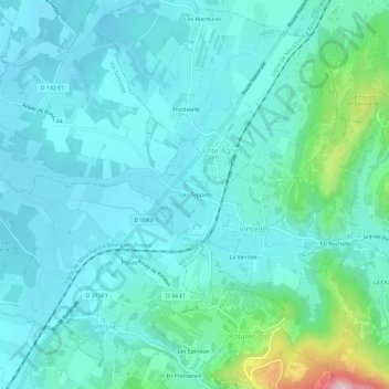
Name: Les Teppes topographic map, elevation, terrain.

Location: Les Teppes, Vincelles, Val-Sonnette, Lons-le-Saunier, Jura, Bourgogne-Franche-Comté, France métropolitaine, 39190, France (46.58373 5.45021 46.62373 5.49021)

Average elevation: 251 m

Minimum elevation: 196 m

Maximum elevation: 538 m

Other topographic maps

Click on a map to view its topography, its elevation and its terrain.

Vercia

France > Bourgogne-Franche-Comté > Jura > Val-Sonnette

Average elevation: 226 m

Vincelles

France > Bourgogne-Franche-Comté > Jura > Val-Sonnette

Average elevation: 237 m

Bonnaud

France > Bourgogne-Franche-Comté > Jura > Val-Sonnette

Average elevation: 202 m

Grusse

France > Bourgogne-Franche-Comté > Jura > Val-Sonnette

Average elevation: 366 m

Gear up for your next adventure:

🧼Biodegradable Camp Soap - Environmentally friendly cleaning for gear and body
👟Sport Hiking Sandals - Breathable footwear for water crossings and camp rest
🔥Emergency Fire Starter - Reliable ignition source for all weather conditions
🥾Hiking Boots - Sturdy boots providing ankle support and traction on rugged trails
⛺Camping Groundsheet - Protect your tent from moisture and dirt

As an Amazon Associate, this site earns from qualifying purchases at no extra cost to you.