
Citlaltépetl topographic map
Interactive map
Click on the map to display elevation.
About this map
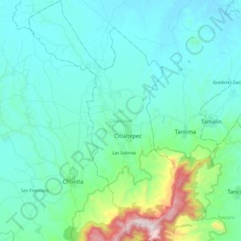
Name: Citlaltépetl topographic map, elevation, terrain.
Location: Citlaltépetl, Veracruz, Mexico (21.25009 -97.95728 21.42760 -97.83784)
Average elevation: 224 m
Minimum elevation: 27 m
Maximum elevation: 1,258 m
The municipality of Citlaltépetl is located in central Veracruz at an altitude between 80 and 1,300 metres (260–4,270 ft), with the south being higher in elevation. It borders the municipalities of Ozuluama to the northwest, Tantima to the northeast and east, Tancoco to the southeast, and Chontla to the west. The municipality covers an area of 81.539 square kilometres (31.482 sq mi) and comprises 0.1% of the state's area.
Other topographic maps
Click on a map to view its topography, its elevation and its terrain.
Alto Lucero
Mexico > Veracruz > Alto Lucero de Gutiérrez Barrios
Alto Lucero, Alto Lucero de Gutiérrez Barrios, Veracruz, 91433, Mexico
Average elevation: 956 m
Virginia
Mexico > Veracruz > Boca del Río
Virginia, Boca del Río, Veracruz, 94249, Mexico
Average elevation: 10 m
Lerdo de Tejada
Mexico > Veracruz > Lerdo de Tejada > Lerdo de Tejada
Lerdo de Tejada, Veracruz, Mexico
Average elevation: 6 m
Fraccionamiento Ciudad Olmeca
Mexico > Veracruz > Coatzacoalcos > Fraccionamiento Ciudad Olmeca
Fraccionamiento Ciudad Olmeca, Coatzacoalcos, Veracruz, Mexico
Average elevation: 6 m
El Vizcaíno
Mexico > Veracruz > El Vizcaíno
El Vizcaíno, Coatzintla, Veracruz, Mexico
Average elevation: 123 m
Mesa Cerrada
Mexico > Veracruz > Mesa Cerrada
Mesa Cerrada, Terrenos del Lote Chichimantla, Tihuatlán, Veracruz, Mexico
Average elevation: 56 m
Torno Largo
Mexico > Veracruz > Torno Largo
Torno Largo, Chacaltianguis, Veracruz, Mexico
Average elevation: 9 m
El Chichón
Mexico > Veracruz > El Chichón
El Chichón, Las Choapas, Veracruz, Mexico
Average elevation: 44 m