Geolocate

Yablanitsa topographic map

Click on the map to display elevation.

About this map

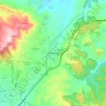
Name: Yablanitsa topographic map, elevation, terrain.

Location: Yablanitsa, Lovech, Bulgaria (42.98542 24.06078 43.06542 24.14078)

Average elevation: 498 m

Minimum elevation: 292 m

Maximum elevation: 957 m

Gear up for your next adventure:

🧥Waterproof Hiking Jacket - Protect yourself from rain and wind while hiking
🔦LED Flashlight - Powerful and long-lasting flashlight for camping and emergencies
🧢Sun Protection Cap - Breathable cap to protect from sun exposure
🏕️Camping Hammock - Integrated protection for sleeping between trees
🧳Compression Sacks - Maximize space in your backpack by shrinking gear

As an Amazon Associate, this site earns from qualifying purchases at no extra cost to you.