
Black Force topographic map
Click on the map to display elevation.
About this map
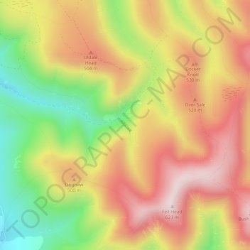
Name: Black Force topographic map, elevation, terrain.
Average elevation: 437 m
Minimum elevation: 190 m
Maximum elevation: 641 m
Other topographic maps
Click on a map to view its topography, its elevation and its terrain.
Deepdale Beck
United Kingdom > England > Westmorland and Furness > South Lakeland > Dent
Average elevation: 280 m
Roudsea Wood
United Kingdom > England > Westmorland and Furness > South Lakeland > Haverthwaite
Average elevation: 7 m