
Make a donation
Gear up for your next adventure:
As an Amazon Associate, this site earns from qualifying purchases at no extra cost to you.
Ilfeld topographic map
Click on the map to display elevation.
Make a donation
Gear up for your next adventure:
As an Amazon Associate, this site earns from qualifying purchases at no extra cost to you.
Ilfeld
Der Poppenberg (Höhe 601 m ü. NN) überragt den Ort im Osten. Ilfeld liegt im Tal der Bere, eines Zuflusses der Zorge. Der Abschnitt oberhalb des Waldbades gilt als landschaftlich reizvoll und wird als Kleines Bodetal bezeichnet. Das eigentliche Ilfelder Tal der Bere ist ein Naturschutzgebiet mit zahlreichen Felsbildungen und Waldpartien, es reicht bis zum Ort Netzkater.
Make a donation
Gear up for your next adventure:
As an Amazon Associate, this site earns from qualifying purchases at no extra cost to you.
About this map
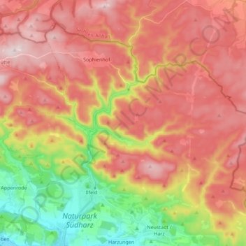
Name: Ilfeld topographic map, elevation, terrain.
Location: Ilfeld, Harztor, Landkreis Nordhausen, Thüringen, Deutschland (51.56384 10.72559 51.64928 10.89421)
Average elevation: 447 m
Minimum elevation: 213 m
Maximum elevation: 628 m
Make a donation
Gear up for your next adventure:
As an Amazon Associate, this site earns from qualifying purchases at no extra cost to you.
Other topographic maps
Click on a map to view its topography, its elevation and its terrain.
Netzkater
Deutschland > Thüringen > Landkreis Nordhausen > Harztor
Etwa 140 Meter nordnordöstlich des Haltepunkts Netzkater mündet der Brandesbach in die Bere. Der Schuppenbach fließt etwas nördlich an Netzkater vorbei und teilt sich 130 Meter von der Raststätte in zwei Arme auf. Der linke mündet auf einer Höhe von 307,1 m in die Bere. Die Mündung liegt nur 120 Meter…
Average elevation: 428 m