
Make a donation
Gear up for your next adventure:
As an Amazon Associate, this site earns from qualifying purchases at no extra cost to you.
Harzburg topographic map
Click on the map to display elevation.
Make a donation
Gear up for your next adventure:
As an Amazon Associate, this site earns from qualifying purchases at no extra cost to you.
About this map
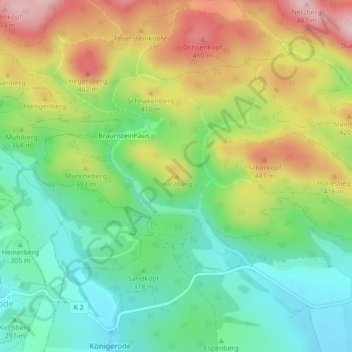
Name: Harzburg topographic map, elevation, terrain.
Average elevation: 339 m
Minimum elevation: 242 m
Maximum elevation: 483 m
Make a donation
Gear up for your next adventure:
As an Amazon Associate, this site earns from qualifying purchases at no extra cost to you.
Other topographic maps
Click on a map to view its topography, its elevation and its terrain.
Ilfeld
Deutschland > Thüringen > Landkreis Nordhausen > Harztor
Der Poppenberg (Höhe 601 m ü. NN) überragt den Ort im Osten. Ilfeld liegt im Tal der Bere, eines Zuflusses der Zorge. Der Abschnitt oberhalb des Waldbades gilt als landschaftlich reizvoll und wird als Kleines Bodetal bezeichnet. Das eigentliche Ilfelder Tal der Bere ist ein Naturschutzgebiet mit zahlreichen…
Average elevation: 447 m