
Ixelles topographic map
Interactive map
Click on the map to display elevation.
About this map
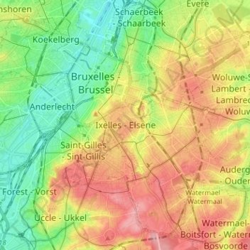
Name: Ixelles topographic map, elevation, terrain.
Location: Ixelles, Bruxelles-Capitale, 1050, Belgique (50.79311 4.32683 50.87311 4.40683)
Average elevation: 62 m
Minimum elevation: 12 m
Maximum elevation: 121 m
Other topographic maps
Click on a map to view its topography, its elevation and its terrain.
Parc Tenbosch
Belgique > Bruxelles-Capitale > Ixelles
Parc Tenbosch, Bascule, Ixelles, Bruxelles-Capitale, 1050, Belgique
Average elevation: 87 m