
Parc Tenbosch topographic map
Interactive map
Click on the map to display elevation.
About this map
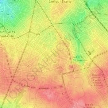
Name: Parc Tenbosch topographic map, elevation, terrain.
Average elevation: 87 m
Minimum elevation: 31 m
Maximum elevation: 116 m
Other topographic maps
Click on a map to view its topography, its elevation and its terrain.
Ixelles
Belgique > Bruxelles-Capitale > Ixelles
Ixelles, Bruxelles-Capitale, 1050, Belgique
Average elevation: 62 m