Geolocate

Fobello topographic map

Click on the map to display elevation.

About this map

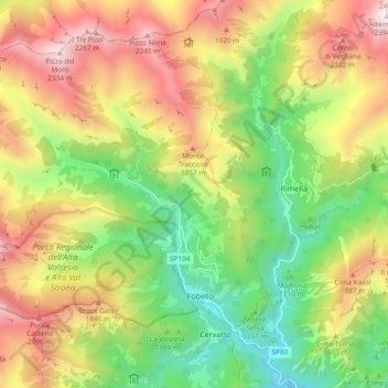
Name: Fobello topographic map, elevation, terrain.

Location: Fobello, Vercelli, Piedmont, 13055, Italy (45.87929 8.08429 45.93395 8.17740)

Average elevation: 1,465 m

Minimum elevation: 744 m

Maximum elevation: 2,368 m

Other topographic maps

Click on a map to view its topography, its elevation and its terrain.

Foresto

Italy > Piedmont > Vercelli > Borgosesia

Average elevation: 647 m

Sn2

Italy > Piedmont > Vercelli > Boccioleto

Average elevation: 1,290 m

Ruse

Italy > Piedmont > Vercelli > Varallo > I Prati

Average elevation: 787 m

Fontana dello Zolfo

Italy > Piedmont > Vercelli > Trino

Average elevation: 149 m

Le Castelle

Italy > Piedmont > Vercelli > Gattinara

Average elevation: 314 m

San Giuseppe

Italy > Piedmont > Vercelli

Average elevation: 1,618 m

Sasso Lungo

Italy > Piedmont > Vercelli > Scopa > Otra

Average elevation: 854 m

Montata

Italy > Piedmont > Vercelli > Varallo

Average elevation: 1,217 m

Gear up for your next adventure:

🪑Ultralight Camping Stool - Compact seating for rest stops during long hikes
🐕Hiking Dog Pack - Let your canine companion carry their own water and food
📷Outdoor Action Camera - Capture high-elevation views and rugged adventures
🏕️Camping Hammock - Integrated protection for sleeping between trees
🛁Quick-Dry Microfiber Towel - Space-saving towel that dries rapidly on the move

As an Amazon Associate, this site earns from qualifying purchases at no extra cost to you.