
Bertioga topographic map
Click on the map to display elevation.
About this map
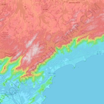
Name: Bertioga topographic map, elevation, terrain.
Average elevation: 437 m
Minimum elevation: -2 m
Maximum elevation: 1,162 m
Other topographic maps
Click on a map to view its topography, its elevation and its terrain.
São Paulo
Brasil > São Paulo > Região Metropolitana de São Paulo
A geologia local é constituída por terrenos policíclicos. representados por rochas metamórficas, migmatitos e granitoides, onde assentam-se sedimentos cenozoicos das bacias sedimentares locais. A altitude do município, tomando como referência o marco zero da cidade na Praça da Sé, é de 760 metros,…
Average elevation: 785 m
Centro Cultural São Paulo
Brasil > São Paulo > Região Metropolitana de São Paulo > São Paulo
Average elevation: 787 m
Alagamento / Inundação
Brasil > São Paulo > Região Metropolitana de Piracicaba > Limeira
Average elevation: 568 m
Piracicaba
Brasil > São Paulo > Região Metropolitana de Piracicaba > Piracicaba
No relevo de Piracicaba apresenta-se predominância de áreas acidentadas, sendo que a depressão é maior na parte central de seu território. Ela continua pelo sentido leste-oeste do curso do rio Piracicaba, aumentando sua acentuação no interior da zona urbana a partir do salto do rio Piracicaba. Essa…
Average elevation: 557 m
Córrego do Gregório
Brasil > São Paulo > Região Metropolitana de São Paulo > Mogi das Cruzes
Average elevation: 782 m
Jundiaí
Jundiaí é um município brasileiro no interior do estado de São Paulo. Localiza-se a 23º11'11" de latitude sul e 46º53'03" de longitude oeste, a uma altitude de 762 metros. Dista 57 quilômetros de São Paulo. Conforme dados do Instituto Brasileiro de Geografia e Estatística (IBGE) de 2019, sua…
Average elevation: 808 m
Rio Claro-SP
Brasil > São Paulo > Região Metropolitana de Piracicaba > Rio Claro
Average elevation: 611 m
Pico dos Marins
Brasil > São Paulo > Região Metropolitana do Vale do Paraíba e Litoral Norte > Cruzeiro
O conjunto principal do Maciço dos Marins é constituído por três pontiagudos cumes de pedra, todos com mais de 2000 metros de altitude e centenas de metros de belos penhascos rochosos. O pico dos Marins, embora seja o mais elevado, é o mais acessível aos montanhistas, graças à sua face norte, menos…
Average elevation: 1,945 m
Pedra do Baú
Brasil > São Paulo > Região Metropolitana do Vale do Paraíba e Litoral Norte > São Bento do Sapucaí
Pedra do Baú (conhecido também como Complexo do Baú ou Complexo da Pedra do Baú) é um conjunto de rochas gnaissicas da Serra da Mantiqueira localizado no município de São Bento do Sapucaí, estado de São Paulo, Brasil. O ponto culminante é a Pedra do Baú (altitude de 1964 metros e 340 metros de…
Average elevation: 1,502 m
Mirante do topo da Serra do Mar
Brasil > São Paulo > Região Metropolitana de São Paulo > Biritiba Mirim
Average elevation: 645 m
São José dos Campos
Brasil > São Paulo > São José dos Campos
No relevo de São José dos Campos apresenta-se predominância de áreas com colinas, que são mais acentuadas a norte, cujas alturas variam de 660 a 975 metros; os chamados mares de morros. Onde está a parte urbana da cidade essas colinas se transformam em terraços tabulares. As serras do Planalto…
Average elevation: 636 m
Serra do Quebra-Cangalha
Brasil > São Paulo > Região Metropolitana do Vale do Paraíba e Litoral Norte > Aparecida
Average elevation: 945 m
São Carlos
A bacia do córrego do Gregório, que nasce em área rural, a leste da cidade de São Carlos, numa região de aproximadamente 900 metros de altitude (onde nascem também o rio Monjolinho e o ribeirão dos Negros, importantes cursos d'água deste município). Tem como afluentes pela margem direita o córrego…
Average elevation: 776 m
Ilha da Queimada Grande
A ilha possui aproximadamente 430.000m², topografia irregular e altitude máxima de 206 m. A profundidade ao redor pode chegar até 45 m. Não possui praias, somente costões rochosos. Um farol automático está instalado na parte mais plana da ilha, mantido e conservado pela Marinha.
Average elevation: 3 m
Ferraz de Vasconcelos
Brasil > São Paulo > Região Metropolitana de São Paulo
Ferraz de Vasconcelos é um dos 39 municípios da Grande São Paulo, pertencente a região do Alto Tietê que contempla dez municípios, contando com uma densidade demográfica elevada e com alto índice de desenvolvimento humano - IDH, sua altitude em relação ao mar, situa-se entre 759 e 760 metros. Quando…
Average elevation: 776 m
Rio Cotia
Brasil > São Paulo > Região Metropolitana de São Paulo > Carapicuíba
Average elevation: 768 m
Pico do Jaraguá
Brasil > São Paulo > São Paulo
Pico do Jaraguá é um dos pontos mais altos do município de São Paulo, no Brasil, elevando-se a uma altitude de 1 135 metros. Situa-se no bairro do Jaraguá, a oeste da serra da Cantareira. Nos seus arredores, foi criado o Parque Estadual do Jaraguá, para conservação da área.
Average elevation: 862 m
Parque Estadual Da Serra Do Mar
Brasil > São Paulo > Região Metropolitana do Vale do Paraíba e Litoral Norte > São Luiz do Paraitinga
Average elevation: 960 m
Parque Campolim
Brasil > São Paulo > Região Metropolitana de Sorocaba > Sorocaba
Average elevation: 619 m
Parque Buenos Aires
Brasil > São Paulo > Região Metropolitana de São Paulo > São Paulo
Inicialmente uma praça, o Parque Buenos Aires foi transformado em parque em 1987. A praça original foi criada a partir de uma área desapropriada pela Prefeitura em 1912, com o objetivo de preservar a vista sobre o Vale do Pacaembu. Criado pelo paisagista francês Bouvard, o projeto original contava com uma…
Average elevation: 782 m
Santo André
Brasil > São Paulo > Região Metropolitana de São Paulo > Santo André
Santo André situa-se a uma altitude média de 760 m acima do nível do mar. Seu relevo, bastante acidentado nas regiões mais afastadas do centro, proporciona um belo espetáculo aos olhos dos ecoturistas. Está também inserido na região dos Planaltos e Serras do Atlântico Leste-Sudeste, possuindo áreas…
Average elevation: 776 m
Quatro e Meio
Brasil > São Paulo > Região Metropolitana de Sorocaba > Quatro e Meio
Average elevation: 637 m
Ribeirão Preto
Brasil > São Paulo > Região Metropolitana de Ribeirão Preto > Ribeirão Preto
Average elevation: 559 m
Rio Boiçucanga
Brasil > São Paulo > Região Metropolitana do Vale do Paraíba e Litoral Norte > São Sebastião
Average elevation: 208 m
São José do Rio Pardo
Brasil > São Paulo > São José do Rio Pardo > São José do Rio Pardo
Average elevation: 764 m
Vila Rio Branco
Brasil > São Paulo > Região Metropolitana de Sorocaba > Itapetininga
Average elevation: 654 m
Parque da Água Branca
Brasil > São Paulo > Região Metropolitana de São Paulo > São Paulo
Average elevation: 752 m
Bairro dos Buenos
Brasil > São Paulo > Região Metropolitana de Sorocaba > Piedade
Average elevation: 815 m
Vila Dominguinhos
Brasil > São Paulo > Região Metropolitana de Sorocaba > Votorantim
Average elevation: 601 m
Praia do Bonete
Brasil > São Paulo > Região Metropolitana do Vale do Paraíba e Litoral Norte > Ubatuba
Average elevation: 43 m
Jardim Faculdade
Brasil > São Paulo > Região Metropolitana de Sorocaba > Sorocaba
Average elevation: 585 m
Parque dos Lagos
Brasil > São Paulo > Região Metropolitana de Campinas > Valinhos
Average elevation: 714 m
Parque Municipal Dom José
Brasil > São Paulo > Região Metropolitana de São Paulo > Barueri
Average elevation: 749 m
Praça da Moça
Brasil > São Paulo > Região Metropolitana de São Paulo > Diadema
Average elevation: 804 m
Rio Itaquera
Brasil > São Paulo > Região Metropolitana de São Paulo > São Paulo
Average elevation: 758 m
Jardim São Paulo
Brasil > São Paulo > Região Metropolitana de Sorocaba > Sorocaba
Average elevation: 628 m
Fazenda Boa Vista
Brasil > São Paulo > Região Metropolitana de Sorocaba > Sarapuí
Average elevation: 571 m
Praça Ibrahim de Almeida Nobre
Brasil > São Paulo > Região Metropolitana de São Paulo > São Bernardo do Campo
Average elevation: 777 m
Praça Conceição Aparecida de Souza Aguiar
Brasil > São Paulo > Região Metropolitana de São Paulo > São Paulo
Average elevation: 776 m
Praça Mateus Leme
Brasil > São Paulo > Região Metropolitana de São Paulo > São Paulo
Average elevation: 772 m
Parque em frente ao museu
Brasil > São Paulo > Região Metropolitana de São Paulo > Franco da Rocha
Average elevation: 765 m
MAAS(Museu Aberto de Astronomia)
Brasil > São Paulo > Região Metropolitana de Campinas > Campinas
Average elevation: 939 m
Santa Branca
Brasil > São Paulo > Região Metropolitana do Vale do Paraíba e Litoral Norte > Santa Branca
Average elevation: 659 m
Praça Angélica Santiago Souza
Brasil > São Paulo > Região Metropolitana de São Paulo > São Paulo
Average elevation: 812 m
Rio Juqueriquerê
Brasil > São Paulo > Região Metropolitana do Vale do Paraíba e Litoral Norte > Caraguatatuba
Average elevation: 212 m
Parque Ecológico Municipal Zila Sisternas Fiorenzo – da Biquinha
Brasil > São Paulo > Região Metropolitana de Sorocaba > Sorocaba
Average elevation: 581 m
Ribeirão Jacuba
Brasil > São Paulo > Região Metropolitana de Campinas > Hortolândia
Average elevation: 607 m
Rio Cubatão
Brasil > São Paulo > Região Metropolitana da Baixada Santista > Cubatão
Average elevation: 9 m
Rio Itaguaré
Brasil > São Paulo > Região Metropolitana da Baixada Santista > Bertioga
Average elevation: 3 m
Praça da santa
Brasil > São Paulo > Região Metropolitana da Baixada Santista > Santos
Average elevation: 35 m
Praça da Bíblia
Brasil > São Paulo > Região Metropolitana de Sorocaba > Cesário Lange
Average elevation: 622 m
Jardim Itália
Brasil > São Paulo > Região Metropolitana de Sorocaba > Sorocaba
Average elevation: 575 m
Praia de Pernambuco
Brasil > São Paulo > Região Metropolitana da Baixada Santista > Guarujá
Average elevation: 9 m
Jardim Fátima
Brasil > São Paulo > Região Metropolitana de Sorocaba > Sorocaba
Average elevation: 570 m
Praça Professora Amélia Cesar Machado de Araújo
Brasil > São Paulo > Região Metropolitana de Sorocaba > Sorocaba
Average elevation: 614 m
Ilhote Praia Grande
Brasil > São Paulo > Região Metropolitana da Baixada Santista > Guarujá
Average elevation: 53 m
Praça Martinho Guedes
Brasil > São Paulo > Região Metropolitana de Sorocaba > Tatuí
Average elevation: 594 m
Nascente (Afloramento D'água do Lençol Fréatico)
Brasil > São Paulo > Região Metropolitana de São Paulo > Franco da Rocha
Average elevation: 764 m
Pedra da Mina
Brasil > São Paulo > Região Metropolitana do Vale do Paraíba e Litoral Norte > Queluz
A Pedra da Mina, ou ocasionalmente o pico da Pedra da Mina, é oficialmente a quarta montanha mais alta do Brasil, com 2798 metros de altitude.
Average elevation: 2,404 m