
Make a donation
Gear up for your next adventure:
As an Amazon Associate, this site earns from qualifying purchases at no extra cost to you.
Jundiaí topographic map
Click on the map to display elevation.
Make a donation
Gear up for your next adventure:
As an Amazon Associate, this site earns from qualifying purchases at no extra cost to you.
Jundiaí
Jundiaí is a municipality in the state of São Paulo, in the Southeast Region of Brazil, located 57 kilometres (35 mi) north of São Paulo. The population of the city is 423,006 (2020 est.), with an area of 431.21 km². The elevation is 761 m. The GDP of the city is U$16.6 billion (R$36.6 billion). The budget for 2013 is U$787 million (R$1.63 billion), according to the official data of the City Hall.
Make a donation
Gear up for your next adventure:
As an Amazon Associate, this site earns from qualifying purchases at no extra cost to you.
About this map
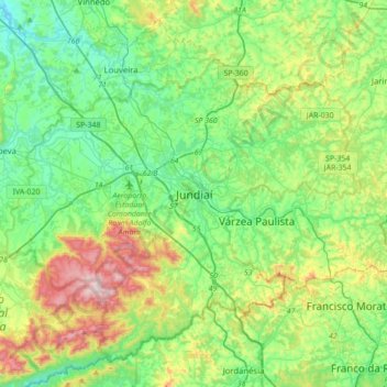
Name: Jundiaí topographic map, elevation, terrain.
Average elevation: 808 m
Minimum elevation: 616 m
Maximum elevation: 1,296 m
Make a donation
Gear up for your next adventure:
As an Amazon Associate, this site earns from qualifying purchases at no extra cost to you.