Geolocate

Valparai topographic map

Click on the map to display elevation.

Valparai

Valparai is located at 10°22′N 76°58′E / 10.37°N 76.97°E / 10.37; 76.97. It is a mid-elevation hill station (Ootacamund is considerably higher) and has an average elevation of 3,914 feet (1,193 m). It is close to the border with Thrissur district of the Kerala state.

Wikipedia (CC-BY-SA 3.0)

About this map

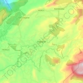
Name: Valparai topographic map, elevation, terrain.

Location: Valparai, Coimbatore, Tamil Nadu, 642127, India (10.28799 76.91573 10.36799 76.99573)

Average elevation: 1,127 m

Minimum elevation: 726 m

Maximum elevation: 1,695 m

Other topographic maps

Click on a map to view its topography, its elevation and its terrain.

Aliyar

India > Tamil Nadu > Valparai > Attakatty

Average elevation: 704 m

Sholayar

India > Tamil Nadu > Valparai > Malakkappara

Average elevation: 907 m

Nadupuni River

India > Tamil Nadu > Valparai > Valparai

Average elevation: 1,104 m

Gear up for your next adventure:

🛶Kayak Dry Bag - Waterproof storage for kayaking adventures
🥾Light Hiking Boots - Lightweight and comfortable boots for day hikes
🔋Lithium AA Batteries - Long-lasting power that performs in extreme cold
💡Compact LED Flashlight - Powerful and portable flashlight for outdoor use
🥾Lightweight Hiking Boots - Boots for comfort and mobility on long hikes

As an Amazon Associate, this site earns from qualifying purchases at no extra cost to you.