Geolocate

Aliyar topographic map

Click on the map to display elevation.

About this map

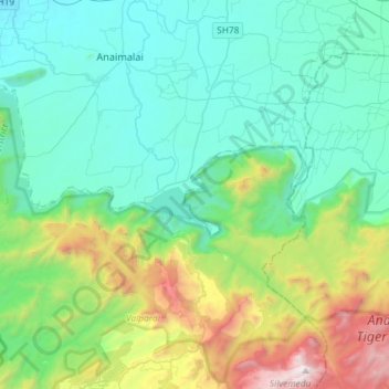
Name: Aliyar topographic map, elevation, terrain.

Location: Aliyar, Attakatty, Valparai, Coimbatore, Tamil Nadu, India (10.33785 76.93899 10.62367 77.09826)

Average elevation: 704 m

Minimum elevation: 187 m

Maximum elevation: 2,503 m

Gear up for your next adventure:

👟Trail Running Shoes - Agile footwear for fast-paced topographic exploration
❄️Traction Ice Cleats - Slip-on spikes for icy trails and winter hiking
🔥Camping Stove - Portable stoves to cook outdoors with ease
🥾Lightweight Hiking Boots - Boots for comfort and mobility on long hikes
🧤Rechargeable Heated Gloves - Extreme warmth for Canadian winter expeditions

As an Amazon Associate, this site earns from qualifying purchases at no extra cost to you.