Geolocate

Corby topographic map

Click on the map to display elevation.

About this map

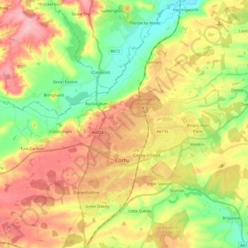
Name: Corby topographic map, elevation, terrain.

Location: Corby, Weldon, North Northamptonshire, England, United Kingdom (52.45446 -0.80795 52.55862 -0.59640)

Average elevation: 98 m

Minimum elevation: 38 m

Maximum elevation: 160 m

Gear up for your next adventure:

🥽Outdoor Goggles - Protective eyewear for outdoor activities
🔋Lithium AA Batteries - Long-lasting power that performs in extreme cold
🥾Trekking Poles - Adjustable trekking poles to reduce knee stress and improve stability
🔥Camping Stove - Portable stoves to cook outdoors with ease
🧥Softshell Hiking Jacket - The perfect balance of wind protection and breathability

As an Amazon Associate, this site earns from qualifying purchases at no extra cost to you.