Geolocate

Fernandina Beach topographic map

Click on the map to display elevation.

About this map

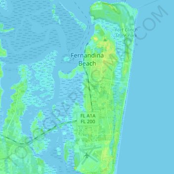
Name: Fernandina Beach topographic map, elevation, terrain.

Location: Fernandina Beach, Nassau County, Florida, 32035, United States (30.59886 -81.47726 30.70583 -81.42636)

Average elevation: 2 m

Minimum elevation: -4 m

Maximum elevation: 17 m

Other topographic maps

Click on a map to view its topography, its elevation and its terrain.

Kings Ferry

United States > Florida > Nassau County

Average elevation: 4 m

Hero

United States > Florida > Nassau County

Average elevation: 5 m

Chester

United States > Florida > Nassau County

Average elevation: 4 m

Gear up for your next adventure:

🧴Sunscreen SPF - Broad-spectrum sunscreen for outdoor activities
🥾Approach Boots - Comfortable boots for hiking and climbing approaches
🧴Insect Repellent - Protect yourself from bugs during outdoor adventures
🥽Outdoor Goggles - Protective eyewear for outdoor activities
🧢Sun Hat - Wide-brim hat for sun protection

As an Amazon Associate, this site earns from qualifying purchases at no extra cost to you.