
Make a donation
Gear up for your next adventure:
As an Amazon Associate, this site earns from qualifying purchases at no extra cost to you.
Kiefersfelden topographic map
Click on the map to display elevation.
Make a donation
Gear up for your next adventure:
As an Amazon Associate, this site earns from qualifying purchases at no extra cost to you.
Kiefersfelden
Kiefersfelden is located in the foothills of the Alps, in the Bavarian part of the Unterinntal, at an altitude of about 484 m (1,587.93 ft) ASL.
Make a donation
Gear up for your next adventure:
As an Amazon Associate, this site earns from qualifying purchases at no extra cost to you.
About this map
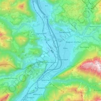
Name: Kiefersfelden topographic map, elevation, terrain.
Location: Kiefersfelden, Landkreis Rosenheim, Bavaria, 83088, Germany (47.60089 12.02835 47.65490 12.20830)
Average elevation: 782 m
Minimum elevation: 458 m
Maximum elevation: 1,977 m
Make a donation
Gear up for your next adventure:
As an Amazon Associate, this site earns from qualifying purchases at no extra cost to you.
Other topographic maps
Click on a map to view its topography, its elevation and its terrain.
Kampenwand-Hauptgipfel
Germany > Bavaria > Landkreis Rosenheim > Aschau im Chiemgau
Average elevation: 1,272 m
Make a donation
Gear up for your next adventure:
As an Amazon Associate, this site earns from qualifying purchases at no extra cost to you.
Make a donation
Gear up for your next adventure:
As an Amazon Associate, this site earns from qualifying purchases at no extra cost to you.
Wasserburg am Inn
Germany > Bavaria > Landkreis Rosenheim > Wasserburg am Inn > Wasserburg am Inn
Average elevation: 477 m
Geigelstein
Germany > Bavaria > Landkreis Rosenheim > Aschau im Chiemgau
Geigelstein is a mountain in Bavaria, Germanywith an elevation of 1,808 meters. It is a mountain within the Chiemgau Alps.
Average elevation: 1,443 m