Geolocate

Geigelstein topographic map

Click on the map to display elevation.

Geigelstein

Geigelstein is a mountain in Bavaria, Germanywith an elevation of 1,808 meters. It is a mountain within the Chiemgau Alps.

Wikipedia (CC-BY-SA 3.0)

About this map

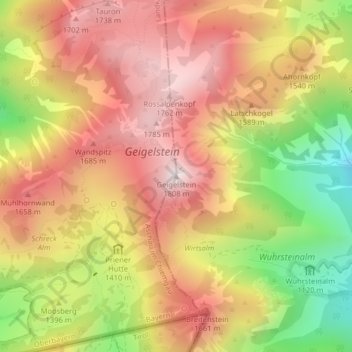
Name: Geigelstein topographic map, elevation, terrain.

Location: Geigelstein, Aschau im Chiemgau, Landkreis Rosenheim, Bavaria, Germany (47.70750 12.33446 47.70760 12.33456)

Average elevation: 1,443 m

Minimum elevation: 972 m

Maximum elevation: 1,789 m

Gear up for your next adventure:

🧢Sun Hat - Wide-brim hat for sun protection
Family Camping Tent - Spacious tent suitable for family camping trips
🕶️Polarized Sunglasses - Protect your eyes with durable polarized lenses
🔋Solar Power Bank - Keep your GPS and devices charged during long outdoor trips
🧼Biodegradable Camp Soap - Environmentally friendly cleaning for gear and body

As an Amazon Associate, this site earns from qualifying purchases at no extra cost to you.