
Oldbury topographic map
Click on the map to display elevation.
About this map
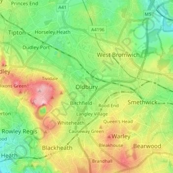
Name: Oldbury topographic map, elevation, terrain.
Average elevation: 161 m
Minimum elevation: 94 m
Maximum elevation: 270 m
Other topographic maps
Click on a map to view its topography, its elevation and its terrain.
Rowley Hills
United Kingdom > England > Sandwell > Tividale
The largest hill, Turner's Hill, is the highest point in the West Midlands county, with an altitude of 269 metres (883 ft) above sea level. Views from the summit include the Clee Hills, Clent Hills, Cannock Chase, and much of Birmingham and the Black Country. The height has also led to the construction of two…
Average elevation: 182 m
Causeway Green Park
United Kingdom > England > Sandwell > Causeway Green > The Ashes
Average elevation: 184 m
Bustleholm Mill Farm Wood
United Kingdom > England > Sandwell > West Bromwich > Bird End
Average elevation: 125 m