Geolocate

Boileau topographic map

Click on the map to display elevation.

About this map

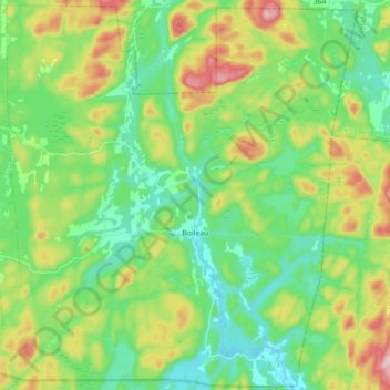
Name: Boileau topographic map, elevation, terrain.

Location: Boileau, Papineau, Outaouais, Quebec, Canada (45.85225 -74.87687 45.97340 -74.69876)

Average elevation: 252 m

Minimum elevation: 164 m

Maximum elevation: 438 m

Other topographic maps

Click on a map to view its topography, its elevation and its terrain.

Lac Suffolk

Canada > Quebec > Papineau > Boileau

Average elevation: 269 m

Gear up for your next adventure:

🥾Waterproof Hiking Boots - Essential footwear for rugged terrain and wet Canadian trails
🧢Outdoor Visor - Breathable visor for sunny hikes
🥾Mountain Trail Shoes - High-traction shoes for mountain trails
🥾Mountaineering Boots - Supportive boots for climbing and high-altitude hiking
🧢Beanie Hat - Keep your head warm in cold weather

As an Amazon Associate, this site earns from qualifying purchases at no extra cost to you.