Geolocate

Molkom topographic map

Click on the map to display elevation.

About this map

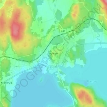
Name: Molkom topographic map, elevation, terrain.

Location: Molkom, Karlstads kommun, Värmland County, 655 60, Sweden (59.58224 13.70867 59.62224 13.74867)

Average elevation: 92 m

Minimum elevation: 65 m

Maximum elevation: 168 m

Other topographic maps

Click on a map to view its topography, its elevation and its terrain.

Kils kommun

Sweden > Värmland County

Average elevation: 104 m

Hammarö kommun

Sweden > Värmland County

Average elevation: 45 m

Sunne kommun

Sweden > Värmland County

Average elevation: 194 m

Hammarö kommun

Sweden > Värmland County

Average elevation: 45 m

Hagfors kommun

Sweden > Värmland County

Average elevation: 257 m

Torsby kommun

Sweden > Värmland County

Average elevation: 356 m

Säffle kommun

Sweden > Värmland County

Average elevation: 89 m

Pottern

Sweden > Värmland County

Average elevation: 145 m

Karlstads kommun

Sweden > Värmland County

Average elevation: 109 m

Filipstads kommun

Sweden > Värmland County

Average elevation: 241 m

Storfors kommun

Sweden > Värmland County

Average elevation: 158 m

Gear up for your next adventure:

🥾Lightweight Hiking Shoes - Comfortable shoes for day hikes
🧴Insect Repellent - Protect yourself from bugs during outdoor adventures
🧢Sun Protection Cap - Breathable cap to protect from sun exposure
🥾Mountain Hiking Boots - High-traction boots for rocky terrain
🔨Vehicle Emergency Tool - Safety tool for remote road trips to trailheads

As an Amazon Associate, this site earns from qualifying purchases at no extra cost to you.