
Virgin Islands topographic map
Click on the map to display elevation.
About this map
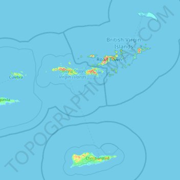
Name: Virgin Islands topographic map, elevation, terrain.
Average elevation: 2 m
Minimum elevation: -1 m
Maximum elevation: 465 m
Other topographic maps
Click on a map to view its topography, its elevation and its terrain.
Montpellier
United States > United States Virgin Islands > Saint Croix District
Average elevation: 59 m
Contentment
United States > United States Virgin Islands > Saint Croix District
Average elevation: 58 m
Little Princess South
United States > United States Virgin Islands > Saint Croix District
Average elevation: 51 m
Morningstar
United States > United States Virgin Islands > Saint Croix District > Morningstar
Average elevation: 68 m