Geolocate

Bosavern topographic map

Click on the map to display elevation.

About this map

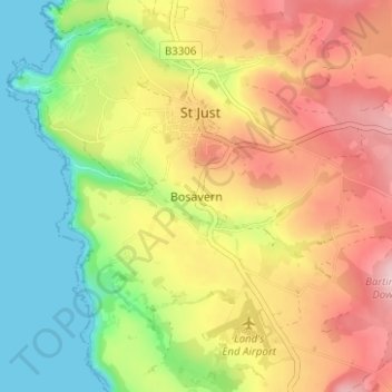
Name: Bosavern topographic map, elevation, terrain.

Location: Bosavern, St Just, Cornwall, England, TR19 7RD, United Kingdom (50.09566 -5.70038 50.13566 -5.66038)

Average elevation: 97 m

Minimum elevation: 0 m

Maximum elevation: 201 m

Other topographic maps

Click on a map to view its topography, its elevation and its terrain.

heathland

United Kingdom > England > Cornwall > St Just > Bosavern > Kelynack

Average elevation: 77 m

Gear up for your next adventure:

🧊Portable Cooler - Keep food and drinks cold during outdoor adventures
🥤Collapsible Travel Cup - Saves space and weight in your mess kit
🔋Lithium AA Batteries - Long-lasting power that performs in extreme cold
🧭GPS Handheld Device - Reliable GPS navigation for outdoor adventures
🔭Compact Binoculars - Lightweight optics for scouting trails and wildlife

As an Amazon Associate, this site earns from qualifying purchases at no extra cost to you.