Geolocate

Wingham topographic map

Click on the map to display elevation.

About this map
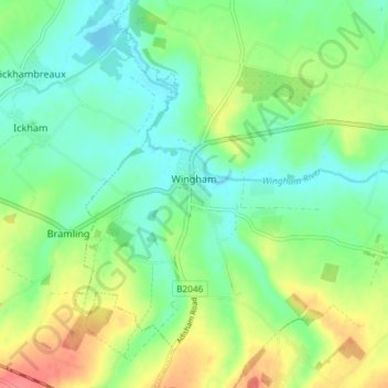
Name: Wingham topographic map, elevation, terrain.

Location: Wingham, Dover, Kent, England, United Kingdom (51.24780 1.19261 51.29379 1.24494)

Average elevation: 22 m

Minimum elevation: 0 m

Maximum elevation: 61 m

Other topographic maps

Click on a map to view its topography, its elevation and its terrain.

Ewell Minnis

United Kingdom > England > Kent > Dover > Alkham

Average elevation: 110 m

Dover

United Kingdom > England > Kent > Dover

Average elevation: 51 m

Finglesham

United Kingdom > England > Kent > Dover > Northbourne

Average elevation: 16 m

Betteshanger

United Kingdom > England > Kent > Dover > Northbourne

Average elevation: 38 m

Kingsdown

United Kingdom > England > Kent > Dover

Average elevation: 20 m

Dover

United Kingdom > England > Kent > Dover

Average elevation: 51 m

Dover

United Kingdom > England > Kent > Dover

Average elevation: 51 m

Ratling

United Kingdom > England > Kent > Dover > Aylesham

Average elevation: 55 m

Dover

United Kingdom > England > Kent > Dover

Average elevation: 51 m

Beech Grove Bruderhof

United Kingdom > England > Kent > Dover > Nonington

Average elevation: 54 m

Gear up for your next adventure:

🥤Collapsible Travel Cup - Saves space and weight in your mess kit
🧰Emergency Multi-Tool - Compact multi-tool for outdoor survival
⛺Camping Essentials - All-in-one gear for a comfortable camping trip
🩹Moleskin Blister Pads - Direct protection for painful foot pressure points
🚲Handlebar Phone Mount - View topographic-map.com live while cycling

As an Amazon Associate, this site earns from qualifying purchases at no extra cost to you.