Geolocate

Princeton topographic map

Click on the map to display elevation.

About this map

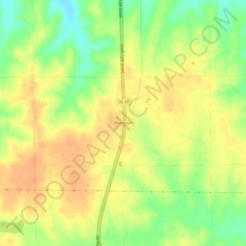
Name: Princeton topographic map, elevation, terrain.

Location: Princeton, Lancaster County, Nebraska, United States (40.55361 -96.72474 40.59361 -96.68474)

Average elevation: 432 m

Minimum elevation: 408 m

Maximum elevation: 446 m

Other topographic maps

Click on a map to view its topography, its elevation and its terrain.

Waverly

United States > Nebraska > Lancaster County

Average elevation: 346 m

Hallam

United States > Nebraska > Lancaster County

Average elevation: 447 m

Gear up for your next adventure:

🥫Freeze-Dried Meals - Lightweight, high-calorie nutrition for multi-day treks
🧥Thermal Layer - Insulating layer for cold outdoor conditions
👟Sport Hiking Sandals - Breathable footwear for water crossings and camp rest
💡Compact LED Flashlight - Powerful and portable flashlight for outdoor use
🧣Merino Neck Gaiter - Protects against wind, sun, and cold at high altitudes

As an Amazon Associate, this site earns from qualifying purchases at no extra cost to you.