Geolocate

Pleasley topographic map

Click on the map to display elevation.

About this map

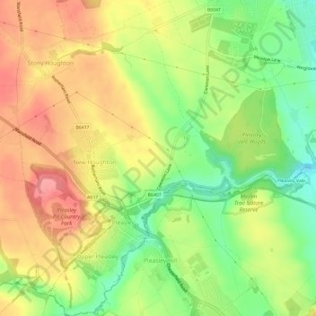
Name: Pleasley topographic map, elevation, terrain.

Location: Pleasley, Bolsover, Derbyshire, East Midlands, England, United Kingdom (53.16440 -1.26928 53.19970 -1.21562)

Average elevation: 141 m

Minimum elevation: 94 m

Maximum elevation: 182 m

Other topographic maps

Click on a map to view its topography, its elevation and its terrain.

Pleasley Vale

United Kingdom > England > Derbyshire > Bolsover

Average elevation: 115 m

Newton

United Kingdom > England > Derbyshire > Bolsover

Average elevation: 143 m

Langwith

United Kingdom > England > Derbyshire > Bolsover

Average elevation: 99 m

Hodthorpe

United Kingdom > England > Derbyshire > Bolsover

Average elevation: 78 m

New Houghton

United Kingdom > England > Derbyshire > Bolsover

Average elevation: 149 m

Hilcote

United Kingdom > England > Derbyshire > Bolsover

Average elevation: 141 m

Shuttlewood

United Kingdom > England > Derbyshire > Bolsover

Average elevation: 109 m

Upper Langwith

United Kingdom > England > Derbyshire > Bolsover

Average elevation: 112 m

Palterton

United Kingdom > England > Derbyshire > Bolsover

Average elevation: 133 m

Westhouses

United Kingdom > England > Derbyshire > Bolsover > Westhouses

Average elevation: 121 m

Gear up for your next adventure:

🦌Outdoor Trail Camera - Monitor wildlife activity near your favorite spots
👟Trail Running Shoes - Agile footwear for fast-paced topographic exploration
🔨Vehicle Emergency Tool - Safety tool for remote road trips to trailheads
🧦Hiking Liner Socks - Thin base layer to prevent friction and blisters
🧥Waterproof Jacket - Lightweight rain jackets for hiking and outdoor activities

As an Amazon Associate, this site earns from qualifying purchases at no extra cost to you.